Cerca
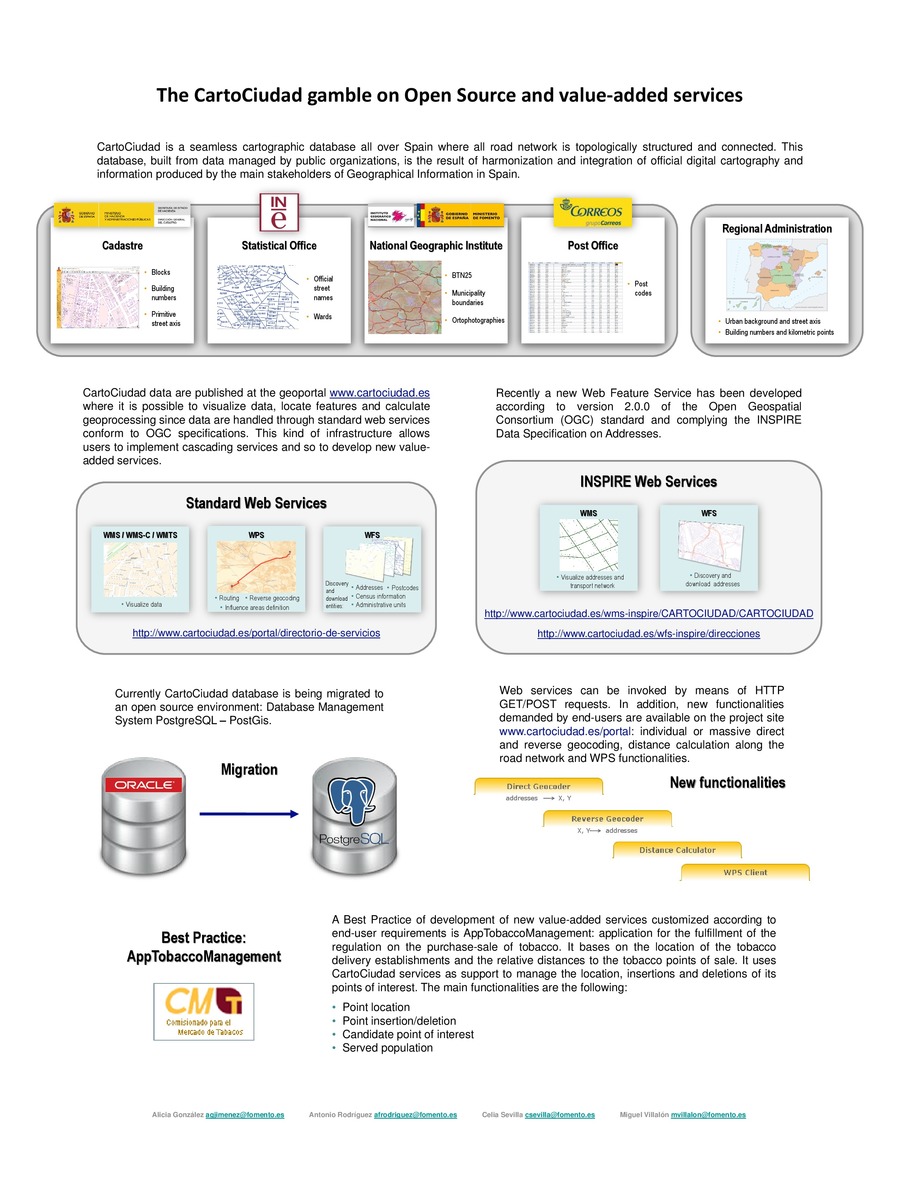
 The CartoCiudad gamble on Open Source and value-added services
(AGILE Digital Editions, 2014-06)
CartoCiudad is a seamless cartographic database all over Spain where all road network is topologically structured and connected. This database, built from data managed by public organizations, is the result of harmonization ...
Exploring the market potential for geo-ICT companies in relation to INSPIRE
(AGILE Digital Editions, 2014-06)
The implementation of INSPIRE can bring new and interesting business opportunities to European geo-ICT companies. Until now, little information has been available on the participation of geo-ICT companies in the implementation ...

Is this Twitter event a disaster?
(AGILE Digital Editions, 2014-06)
Social media services such as Twitter have become an important channel for reporting real-world events. For example, they can describe the current situation during a disaster. The decisions in crises management are based ...

Capability of movementfeatures extracted fromGPS trajectoriesforthe classification of fine‐grained behaviors
(AGILE Digital Editions, 2014-06)
Recent advances in tracking technologies provide an unprecedented opportunity for a better understanding of animal movement. Data from multiple sensors can be used to capture crucial factors deriving the behaviors of the ...
Real-time detection of anomalous paths through networks
(AGILE Digital Editions, 2014-06)
The proliferation of increasingly inexpensive mobile devices capable of transmitting accurate positional information to other devices and servers has led to a variety of applications ranging from health situation monitoring ...
Workforce Demand Assessment to Shape Future GI-Education – First Results of a Survey
(AGILE Digital Editions, 2014-06)
Geographic Information Science & Technology (GIS&T) is constantly evolving in scientific and technological terms. In 2006 the GIS&T
Body of Knowledge (BoK) initiative has provided a domain inventory that serves as a ...
It’s GIrls’ Day! What sketch maps show about girls’ spatial knowledge
(AGILE Digital Editions, 2014-06)
This paper describes the analysis of sketch maps from girls who participated in the Girls’ Day annual event in Germany. The event caters to girls from Grades 7 – 10 as an opportunity to experience various jobs that might ...
A Spatial Approach to Surveying Crime‐problematic Areas at the Street Level
(AGILE Digital Editions, 2014-06)
Reaching far beyond the realm of geography and its related disciplines, spatial analysis and visualization tools now actively support the
decision-making processes of law enforcement agencies. Interactive mapping of crime ...
Latest Developments and activities in the Spanish NSDI
(AGILE Digital Editions, 2014-06)
The Spanish NSDI Geoportal was opened on June 2004 and has evolving continuously with the support of a healthy collaborative community composed by public and private sector, academia and citizens. INSPIRE Directive has ...

Spatiotemporal data complexity in electronic airport layout plan and its visualization
(AGILE Digital Editions, 2014-06)
Airports GIS is a web portal consisting of a few application modules. It allows authorized users of FAA (Federal Aviation Administration) to submit changes to airport data. One of these applications is electronic Airport ...


