Mostra el registre parcial de l'element
Agile access to sensor network
| dc.contributor | Huerta Guijarro, Joaquín | |
| dc.contributor | Schade, Sven | |
| dc.contributor | Granell Canut, Carlos | |
| dc.contributor.author | Trilles, Sergio | |
| dc.contributor.author | Belmonte-Fernández, Óscar | |
| dc.contributor.author | Díaz Sánchez, Laura | |
| dc.contributor.author | Huerta, Joaquin | |
| dc.date.accessioned | 2014-08-27T12:21:09Z | |
| dc.date.available | 2014-08-27T12:21:09Z | |
| dc.date.issued | 2014-06 | |
| dc.identifier.isbn | 9789081696043 | |
| dc.identifier.uri | http://hdl.handle.net/10234/99492 | |
| dc.description | Ponencias, comunicaciones y pósters presentados en el 17th AGILE Conference on Geographic Information Science "Connecting a Digital Europe through Location and Place", celebrado en la Universitat Jaume I del 3 al 6 de junio de 2014. | ca_CA |
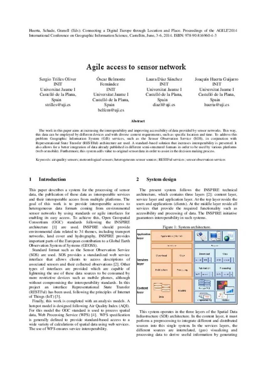
| dc.description.abstract | The work in this paper aims at increasing the interoperability and improving accessibility of data provided by sensor networks. This way, this data can be employed by different devices and with diverse context requirements, such as specific location and time. To address this problem Geographic Information System (GIS) services, such as the Sensor Observation Service (SOS), in conjunction with Representational State Transfer (RESTFul) architecture are used. A standard-based solution that increases interoperability is presented. It also allows for a better integration of data already published in different semi-structured formats in order to be used by various platforms (web or mobile). Furthermore, this system adds value to original sensor data in order to assist in the decision making process. | ca_CA |
| dc.format.extent | 4 p. | ca_CA |
| dc.format.mimetype | application/pdf | ca_CA |
| dc.language.iso | eng | ca_CA |
| dc.publisher | AGILE Digital Editions | ca_CA |
| dc.relation.isPartOf | Huerta, Schade, Granell (Eds): Connecting a Digital Europe through Location and Place. Proceedings of the AGILE'2014 International Conference on Geographic Information Science, Castellón, June, 3-6, 2014. ISBN: 978-90-816960-4-3 | ca_CA |
| dc.rights.uri | http://rightsstatements.org/vocab/CNE/1.0/ | * |
| dc.subject | Association of Geographic Information Laboratories for Europe ( AGILE) Conference | ca_CA |
| dc.subject | Geographic Information Science | ca_CA |
| dc.subject | Información geográfica | ca_CA |
| dc.subject | air quality sensors | ca_CA |
| dc.subject | meteorological sensors | ca_CA |
| dc.subject | heterogeneous sensor sources | ca_CA |
| dc.subject | RESTFul services | ca_CA |
| dc.subject | sensor observation services | ca_CA |
| dc.title | Agile access to sensor network | ca_CA |
| dc.type | info:eu-repo/semantics/bookPart | ca_CA |
| dc.rights.accessRights | info:eu-repo/semantics/openAccess | ca_CA |
Fitxers en aquest element
Aquest element apareix en la col·lecció o col·leccions següent(s)
Elements relacionats
Mostrant elements relacionats per títol, autoria, creador i matèria.
-
 Desarrollo de aplicación SCADA para la supervisión de un sensor de partículas
Universitat Jaume I (2020-07-16)En el ámbito industrial existe el grave problema que genera el exceso de sílice en algunos puestos de trabajo. A partir de la nueva normativa desde la Unión Europea que permite duplicar la cantidad de sílice en el ambiente, ...
Desarrollo de aplicación SCADA para la supervisión de un sensor de partículas
Universitat Jaume I (2020-07-16)En el ámbito industrial existe el grave problema que genera el exceso de sílice en algunos puestos de trabajo. A partir de la nueva normativa desde la Unión Europea que permite duplicar la cantidad de sílice en el ambiente, ... -
 Development of Conductivity Sensors for Multi-Phase Flow Local Measurements at the Polytechnic University of Valencia (UPV) and University Jaume I of Castellon (UJI)
MDPI (2017)This paper describes all the procedures and methods currently used at UPV (Universitat Politécnica de Valencia) and UJI (University Jaume I) for the development and use of sensors for multi-phase flow analysis in vertical ...
Development of Conductivity Sensors for Multi-Phase Flow Local Measurements at the Polytechnic University of Valencia (UPV) and University Jaume I of Castellon (UJI)
MDPI (2017)This paper describes all the procedures and methods currently used at UPV (Universitat Politécnica de Valencia) and UJI (University Jaume I) for the development and use of sensors for multi-phase flow analysis in vertical ... -
Mobile Access to Sensor Network: A Use Case on Wildfire Monitoring
Springer International Publishing (2014)These networks provide large volumes of data in many different formats, resolution and scales. The data are of different types and character: from meteorological conditions to air quality and the concentrations of pollutants ...


