Buscar

 Geographic Information Technologies for analysing the digital footprint of tourists
(AGILE Digital Editions, 2014-06)
As part of a study on the use of the city by visitors, this paper discusses the technical solution adopted in order to analyse and exploit the
geo-digital footprint generated by the said visitors using GPS devices.
Enhancing the role of Citizen Sensors in Mapping: COST Action TD1202
(AGILE Digital Editions, 2014-06)
This article introduces a strategic initiative, COST Action TD1202, focused on the role of citizen sensors in mapping. It outlines the Action’s scope, aims and current status. In particular, the article outlines the potential ...


How Earth Observation, Crop Modeling, and ICT can help rice cultivation: the ERMES project
(AGILE Digital Editions, 2014-06)
Due to pressure of food demand, increased price competition and demand for sustainable farming practices, it’s increasingly important to
optimize agricultural practices. The European FP7 project ERMES focuses specifically ...
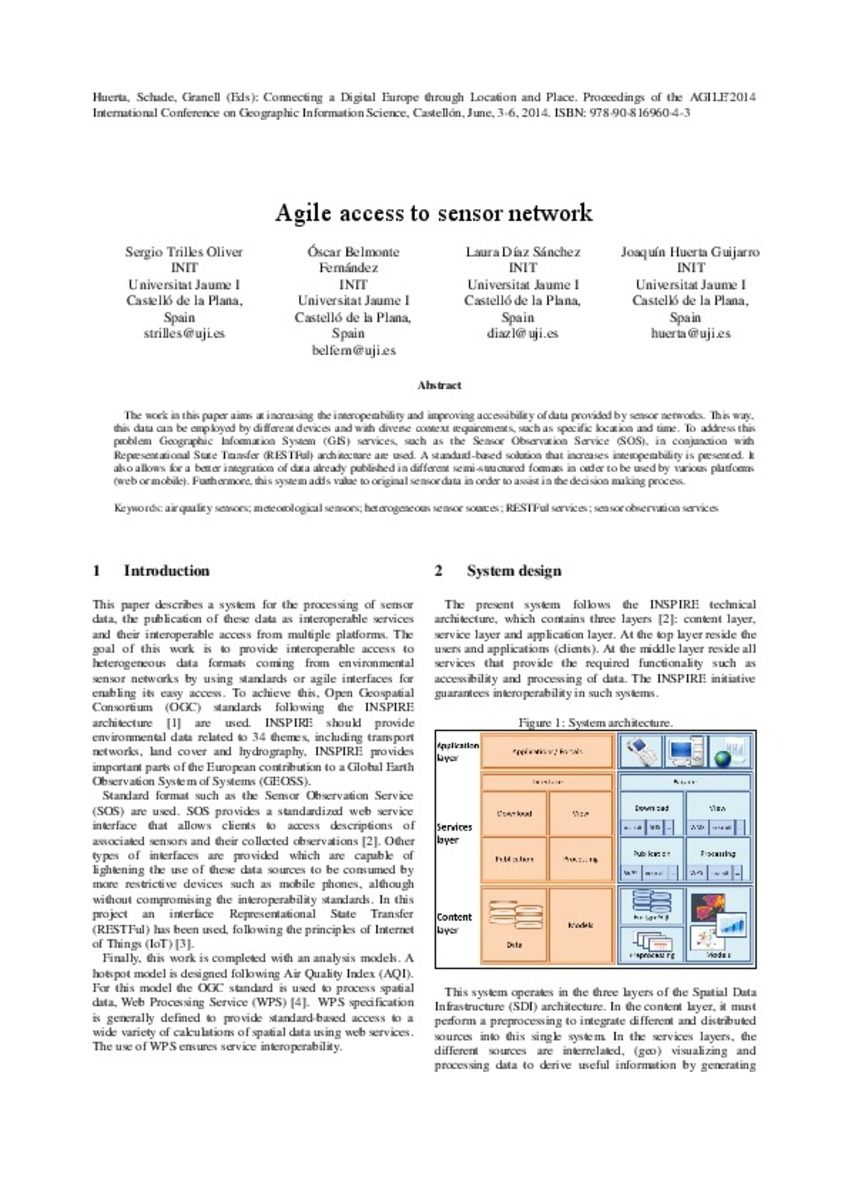
Agile access to sensor network
(AGILE Digital Editions, 2014-06)
The work in this paper aims at increasing the interoperability and improving accessibility of data provided by sensor networks. This way, this data can be employed by different devices and with diverse context requirements, ...

Utilization of NoSQL database for disaster preparedness
(AGILE Digital Editions, 2014-06)
Nowadays, in the age of big data, geodatabases become more critical with respect to geospatial data volume, variety and capacity. It is required that geodatabases must be capable enough to cope with high stakes of geospatial ...

Towards initiating OpenLandMap founded on citizens’ science: The current status of land use features of OpenStreetMap in Europe
(AGILE Digital Editions, 2014-06)
Land use inventories are important information sources for scholarly research, policy-makers, practitioners, and developers. A considerable amount of effort and monetary resources have been used to generate global/regional/local ...
Multi-sensory Integration for a digital earth nervous system
(AGILE Digital Editions, 2014-06)
The amount of geospatial data is increasing, but interoperability issues hinder integrated discovery, view and analysis. This paper suggests
an illustrative and extensible solution to some of the underlying challenges, ...
Estimating Moving Regions out of Point Data – from Excavation Sites in the Amazon region to Areas of Influence of Prehistoric Cultures
(AGILE Digital Editions, 2014-06)
How can we derive the changing area of influence of specific cultures from only a few excavation sites in the Amazon region? The
approach used for calculating areas of influence for several time intervals strongly depends ...

Cropland capture: A gaming approach to improve global land cover
(AGILE Digital Editions, 2014-06)
Accurate and reliable information on global cropland extent is needed for a number of applications, e g. to estimate potential yield losses in the wake of a drought or for assessing future scenarios of climate change on ...


